Category Archives: Geomorphology

A bunch of new research

A bunch of new research

I have a whole bunch of new papers recently published to tell you about. I can’t take (all) the credit though as they have been led by amazing colleagues. Huge shout out especially to Josh Wolstenholme who has been working hard to publish various bits of his PhD research.

Hydro-geomorphological modelling of leaky wooden dam efficacy from reach to catchment scale with CAESAR-Lisflood 1.9jGeoscientific Model Development.

The first paper in this update led by Josh covers the modelling work performed for his PhD. He used an enhancement of CAESAR-Lisflood I wrote that allows users to represent leaky woody dames in the model, including those with flow gaps underneath. This provides an ideal tool to simulate the long-term changes natural flood management can cause in rivers. Josh’s research demonstrates the feasibility of this including verification against field observations.

Localised geomorphic response to channel-spanning leaky wooden damsEGUSphere Pre-print (under review for Earth Surface Dynamics).

This is the second paper Josh has produced from his PhD research, currently under review but you can access the pre-print. Whilst the paper above covers his modelling work, this one covers his fieldwork. This includes some enjoyable, yet very cold, trips to Dalby Forest, North Yorkshire, and the installation of trail cams. The field work observed changes to the river before and after natural flood management interventions had been undertaken.

Flood hazard amplification by intra-event sediment transportResearchSquare Pre-print (under review for Nature Earth & Environment).

I cannot tell you how happy I am to see this paper out! Five years ago this was going to my big paper, the one with significant findings rather than some niche model sensitivity tests. But every time I made progress something in the model popped up to frustrate me. After I left Hull in 2021 I let it sit. Last year, Josh picked it up again and brought fresh eyes and energy to it. He has done a brilliant job and made it his own.

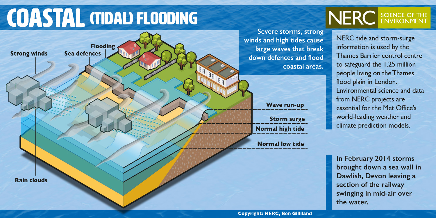
The way we assess flood risk assumes rivers do not change shape during floods. In the majority of cases this is a reasonable assumption, however, the modelling work here shows that it is not always the case. Large amounts of sediment can be transported downstream and deposited, increasing flood inundations and volumes during later stages of the same event.

Using 360° immersive storytelling to engage communities with flood riskGeoscience Communication

This paper, led by Katie Parsons, describes the work we did co-creating educational materials to support the Help Callum and Help Sali 360 videos. The videos came about when I worked with Alison Lloyd-Williams to use my immersive storytelling research to tell the real-life stories of flood-affected children that were shared through Alison’s research. Katie brought her education expertise to work with children, young people, and teachers to create resources to use the videos in the classroom.

I have been so privileged to get to collaborate with amazing and wonderful researchers like Josh and Katie. It’s also great to see them work together on the HedgeHunter’s project too. I had nothing to do with this but it is really cool work:

Automated identification of hedgerows and hedgerow gaps using deep learningRemote Sensing in Ecology and Conservation.

Back in 2020, just before the lockdown, Katie took part in my NERC-funded Earth Arcade Academy project with a project called INSECURE and it grew massively since (nothing to do with me!). Katie used creative methods to foster intergenerational engagement in communities at risk of coastal erosion. Even though my contribution was tiny and remote, it is such a great project I am going to pretend I had a small hand in it!:

Crumbling cliffs and intergenerational cohesivity: A new climate praxis model for engaged community action on accelerated coastal changeEGUSphere Pre-print (under review for Geoscience Communciation)

Both Josh and Katie are now at Loughborough University and working on new projects together. I cannot wait to see what they will produce.

This article was originally posted in the Imagination Engines newsletter. To receive this content in your email weeks earlier, subscribe using the box below.

Views expressed are my own.

Improving environmental models - less is more

Improving Environmental Models: Less is More

I am speaking to the environmental modellers now. Imagine, you have been asked to make your model better, to improve its performance, and generally make it a more useful tool for decision makers. You have got a generous budget and free reign to do whatever you want. Just take a short moment to think about what you would do.

When you read the paragraph above, what did you think about? I am going to guess it was something along the lines of “Amazing, I’m going to add in representation of that process the model currently doesn’t have”. Maybe it was how you would increase the resolution of the model or how you would collect more data to add into it.  I am also going to guess that you did not think about what you would take away from your model.

A recent study by Adams et al (2021), published in Nature, found that we are hard wired to solve solutions by adding things in rather than looking at taking things away, despite the fact that taking something away would have been the better and more efficient way. I really encourage you to watch the video below that nicely summarises this work.

I know when I have approached modelling problems, my go to has been to add something in, rather than to consider what could be taken away. Yet, often when we add in new processes or increase the resolutions we may improve our outputs but we also increase the complexity, resulting in slower processing speeds and increased uncertainties. When assessing the models on how useful they are to decision makers, we may have actually made them worse.

The European Centre for Medium Weather Forecasts (ECMWF) have recently upgraded their Integrated Forecast System. One of the improvements they made is a great example of taking something away to solve a problem. Previously, they had stored numbers using 64-bits of memory within their computers. Using 64-bit over 32-bit allows you to store bigger numbers, i.e., use more decimal places and increase the precision of the output. This sounds like it is better, it sounds like if you had the option to go to 128-bit you ought to as you could have even bigger numbers and even greater precision still. The flipside is that storing and computing with bigger numbers takes a tiny bit longer to do each time and when multiplied over the vast number of sums the supercomputers at ECMWF do, this adds up. They realised that they did not need that level of precision and, for many processes, using 32-bit instead of 64-bit made little different to the output. Making the switch reduced the computational load by 40%, meaning swifter, and therefore more useful, results.

Photo by Gabriela Palai on Pexels.com

This is not anything new in numerical modelling and reduced-complexity approaches are popular and long established. However, these were designed with a conscious effort to take things away and it is when we stop making this conscious effort that we default back to adding things in as a first option. This is especially true, as the video tells us, when our cognitive load is high. Next time you sit down to solve a modelling problem make sure to remind yourself to stop and think – what can I take away to make this better?

Chris

Fridays are my non-work day so I try to write a short blog post on my thoughts about environmental modelling, games, or really anything else that is on my mind. The purpose is for nothing more than the love of writing and for practice but I do hope you enjoy them. For the avoidance of any doubt, all of the views and opinions I express in these blogs are very much my own and not those of my employer.

Below sea level does not mean below the sea

Below Sea Level does not mean Below the Sea.

This post represents my own views and is not intended to represent the views of my employer, present or past.

I’ve been umm-ing and ah-ing for a couple of months now about whether to write this blog, but I think I have finally had enough. You see, in Hull, we are at risk of flooding from the sea, or more specifically, the Humber Estuary. This risk emerges when low pressure out in the North Sea, caused by the storms, which can be common in the winter, effectively suck up the sea causing it to raise a little. High winds whip up waves, and these add a little more height to the water. All of this has the potential to raise the level of the sea, for a few hours, by up to a couple of metres. On December 5th 2013, a storm surge (as these events are called) raised the water level in the Humber by 1.7 metres.

The added complexity to this are the tides. The difference in the water level between low and high tide at Hull, according to the Associated British Ports (ABP) is between 3.5 m for a neap tide, and 6.9 m for a spring tide – this staggers the level we have determined to be 0 m, or sea level. This means the risk of flooding is all a matter of timing. If, on December 5th 2013, the storm passed by a few hours earlier or later the surge would have aligned with the low tide, and the additional 1.7 m would have barely been noticed by anyone. However, it was timed with a high spring tide, resulting in record water levels in the Humber and caused flooding in Hull and around the Estuary.

Coastal flooding

Graphic showing how coastal, or tidal, flooding forms. This was the type of flooding which occurred around the Humber in 2013. Thanks to NERC for producing these great resources. 

When we design and build flood defences on the coast we don’t build them to just hold back tidal levels of the water, but also to defend against enhanced water levels produced by storm surges. Since 2013, the defences around Hull have been updated and a repeat of the event would result in little or no flooding in the city – I don’t know the exact level of the defence, but we can say that it is able to contain sea levels of at least 1.7 m higher than the highest natural tidal level.

A big issue facing Hull is sea level rise. Sea level has been rising since the end of last ice age, and is set to continue in the future. On top of this, the climate change caused by our industry is accelerating this. Our best estimates for the Humber area, assuming that as a species we continue increasing our influence on the climate, suggest the sea level will be around 1 m higher in 100 years than they are today – this will increase the risk of flooding and we need to ensure that the public understand this and that we continue to invest in improving the standards of our defences to keep pace.

On the first point, talking to residents of Hull about the risk of flooding from the Estuary provokes two responses. (1) There is a lack of appreciation of the risk from the Estuary, and when I start to talk about the 2013 flooding, people tend to share with me their experiences of the 2007 flooding (a surface flooding event). (2) People tend to feel that there is no point in doing anything as “Hull will be underwater in 100 years”. This latter point is what I want to discuss here, it’s a common perception and leads to a kind of apathy where people become disengaged with flood risk and actions to mitigate for it, but it is wrong.

It is a deeply held belief that goes beyond even the city – in 2015, Dr Hugh Ellis, the now Head of the Town and Country Planning Association (TCPA), made the claim that the city would be underwater in 100 years –

“We need to think about moving populations and we need to make new communities. We need to be thinking, does Hull have a future?” (Source – Daily Telegraph)

Ok, he was trying to make a valid point, one that sea level rise is going to increase the risk of flooding for coastal cities, but I don’t think bold, and inaccurate statements, like this are helpful, and they only result in residents of the areas becoming disengaged – why do anything about the problem if it is futile?

But where does this idea come from? Why are people convinced Hull will be underwater in 100 years? Why do people think it will become the “Venice of the North”? Well, look at the map below –

surging seas

Screenshot from Climate Central’s Surging Seas Risk Zone Map – this shows the Humber Region, UK, with a 1 m sea level applied.

This is map of ‘risk’ taken for the Humber area. For areas outside of the US, the Risk Map has been produced using a map of land heights obtained from space by the Shuttle Radar Topography Mission, which mapped the entire globe at resolutions between 30 m and 90 m. The areas shaded in blue are all those ‘below sea level’ – normally 0 m, but in the map above I’ve set it at 1 m to represent the predicted sea level in 100 years time. Hull isn’t labelled on that map, but it basically the large blue area between North Ferriby and Hedon – very clearly ‘under water’.

But the method is problematic, it’s too simple. An average measurement of land heights over a 30 m area is fantastic when considering it is for the whole planet, however for determining flood risk it’s a bit rubbish. It smooths the land surface, removing obstacles, like wall, roads and buildings, and crucially, flood defences. The method also ignores ‘hydraulic connectivity’*, basically meaning that for water to flood an area it has to have a source of water and a route for it to get there – flood defences work by removing this hydraulic connectivity and this is why today the Humber region, and much of Holland, is close to or below sea level, but not under the sea.

To understand the actually risk posed by sea level rise requires a more complex model, one which accounts for tides, contains more detailed data, and more importantly includes flood defences. Our model (paper here behind paywall) does this, and a version of it is incorporated into Humber in a Box – with both of these we observe no flooding around the Estuary for natural tides with a 1 m sea level rise. This is because the defences are built to hold back the much higher water levels caused by storm surges.

Climate Central have been careful to refer to this shading as ‘risk’, and not direct inundation by the sea, but the use of blue and not making this explicit anywhere opens this up to mis-interpretation where ‘below sea level’ means ‘below the sea’. This is clearly happening – see this article in the Conversation, which made the BBC Sports pages, which used the app to suggest Everton’s new stadium “could end up underwater” in the future, or this article shared by the awesome Geomorphology Rules  Facebook page, suggesting that coastal cities in the US will be “drowning in water”.

Sea level rise is going to increase the risk of flooding in coastal cities but they are not going to be under water. The risk does not emerge from the tidal water levels, which will most likely be contained by present defences, or those to be built in the future. However, the risk from storm surges will increase – the likelihood of events like December 5th 2013 is set it increase, both in strength and frequency, and with 1 m extra sea level in 100 years our defences will need to be updated to cope with the enhanced levels. This will take a lot of money, a lot of effort, a lot of political will, and this requires the buy in and support of the residents of these areas. Telling them, or suggesting, that they will be required to relocate will only achieve the opposite.

Sea level rise and the related flood risk is a complex issue and we can’t keep trying to find simple answers.

*For areas within the US, the method uses much higher resolution height data, and accounts for hydraulic connectivity by shading areas differently.